| 
Oman Geography
A
vast desert plain covers most of central Oman, with mountain ranges
along the north (Jebel Akhdar) and southeast coast, where the
country's main cities are also located: the capital city Muscat,
Matrah and Sur in the north, and Salalah in the south. Oman's
climate is hot and dry in the interior and humid along the coast.
During past millennia Oman was covered by ocean. Fossilized shells
exist in great numbers in areas of the desert up to 50 miles from
the modern coastline.
Oman Exclaves and enclaves
The
peninsula of Musandam (Musandem), which has a strategic location
on the Strait of Hormuz, is separated from the rest of Oman by
the United Arab Emirates and is thus an exclave.
Oman
has one other exclave, inside UAE territory, known as Wadi-e-Madhah.
It is located halfway between the Musandam Peninsula and the rest
of Oman . Belonging to Musandam governorate, it covers approximately
75 square kilometres (29 sq mi). The boundary was settled in 1969.
The north-east corner of Madha is closest to the Khorfakkan-Fujairah
road, barely ten metres (30 ft) away. Within the exclave is an
UAE enclave called Nahwa, belonging to the Emirate of Sharjah.
It is about eight kilometres (five mi) on a dirt track west of
the town of New Madha. It consists of about forty houses with
its own clinic and telephone exchange .
Cyclone
Gonu
Oman
was hit by Cyclone Gonu on June 6. Large areas in the capital
area region in the Governorate of Muscat and in Amerat and Quriyat
were severely affected. Gonu first hit the southern city of Sur
late on June 5, 2007.
Interestingly, Oman is one of the few countries
having no National Red Crescent or Red Cross Society.
Location
Oman is located in the southeastern quarter of the Arabian Peninsula
and, according to official estimates, covers a total land area
of approximately 300,000 square kilometers; foreign observer estimates,
however, are about 212,000 square kilometers. The land area is
composed of varying topographic features: valleys and desert account
for 82 percent of the land mass; mountain ranges, 15 percent;
and the coastal plain,
3 percent.
The sultanate is flanked by the Gulf of
Oman, the Arabian Sea, and the Rub al Khali (Empty Quarter) of
Saudi Arabia, all of which contributed to Oman's isolation. Historically,
the country's contacts with the rest of the world were by sea,
which not only provided access to foreign lands but also linked
the coastal towns of Oman. The Rub al Khali, difficult to cross
even with modern desert transport, formed a barrier between the
sultanate and the Arabian interior. The Al Hajar Mountains, which
form a belt between the coast and the desert from the Musandam
Peninsula (Ras Musandam) to the city of Sur at Oman's easternmost
point, formed another barrier. These geographic barriers kept
the interior of Oman free from foreign military encroachments.
Geographic coordinates: 21°00'N, 57°00'E
Geographical regions
Natural features divide the country into
seven distinct areas: Ruus al Jibal, including the northern Musandam
Peninsula; the Al Batinah coastal plain; the Muscat-Matrah coastal
area; the Oman interior, comprising Jabal al Akhdar (Green Mountain),
its foothills, and desert fringes; the barren coastline south
to Dhofar; Dhofar region in the south; and the offshore island
of Masirah.
Detailed
map of Oman |
Topographic
map of Oman. |
Ruus al Jibal
The northernmost area, Ruus al Jibal, extends from the Musandam
Peninsula to the boundary with the United Arab Emirates (UAE)
at Hisn al Diba. It borders the Strait of Hormuz, which links
the Persian Gulf with the Gulf of Oman, and is separated from
the rest of the sultanate by a strip of territory belonging to
the UAE. This area consists of low mountains forming the northernmost
extremity of the Al Hajar al Gharbi (Western Al Hajar) Mountains.
Two inlets, Elphinstone (Khawr ash Shamm) and Malcom (Ghubbat
al Ghazirah), cleave the coastline about one third of the distance
from the Strait of Hormuz and at one point are separated by only
a few hundred meters of land. The coastline is extremely rugged,
and the Elphinstone Inlet, sixteen kilometers long and surrounded
by cliffs 1,000 to 1,250 meters high, has frequently been compared
with fjords in Norway.
Al Batinah
The UAE territory separating Ruus al Jibal from the rest of Oman
extends almost as far south as the coastal town of Shinas. A narrow,
well-populated coastal plain known as Al Batinah runs from the
point at which the sultanate is reentered to the town of As Sib,
about 140 kilometers to the southeast. Across the plains, a number
of wadis, heavily populated in their upper courses, descend from
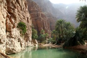
the Al Hajar al Gharbi Mountains to the south. A ribbon of oases,
watered by wells and underground channels (falaj), extends the
length of the plain, about ten kilometers inland.
Muscat-Matrah coastal area
South of As Sib, the coast changes character. For about 175 kilometers,
from As Sib to Ras al Hadd, it is barren and bounded by cliffs
almost its entire length; there is no cultivation and little habitation.
Although the deep water off this coast renders navigation relatively
easy, there are few natural harbors or safe anchorages. The two
best are at Muscat and Matrah, where natural harbors facilitated
the growth of cities centuries ago.
Oman interior
West of the coastal areas lies the tableland of central Oman.
The Al Hajar Mountains form two ranges: the Al Hajar al Gharbi
Mountains and the Al Hajar ash Sharqi (Eastern Al Hajar) Mountains.
They are divided by the Wadi Samail (the largest wadi in the mountain
zone), a valley that forms the traditional route between Muscat
and the interior. The general elevation is about 1,200 meters,
but the peaks of the high ridge known as Al Jabal al Akhdar (Green
Mountain)--which is considered a separate area but is actually
part of the Al Hajar al Gharbi Mountains--rise to more than 3,000
meters in some places. Al Jabal al Akhdar is the only home of
the Arabian tahr, a unique species of wild goat. In the hope of
saving this rare animal, Sultan Qabus ibn Said has declared part
of Al Jabal al Akhdar a national park. Behind the Al Hajar al
Gharbi Mountains are two inland regions, Az Zahirah and inner
Oman, separated by the lateral range of the Rub al Khali. Adjoining
the Al Hajar ash Sharqi Mountains are the sandy regions of Ash
Sharqiyah and Jalan, which also border the desert.
Dhofar region
Dhofar region extends from Ras ash Sharbatat to the border of
Yemen. Its exact northern limit has never been defined, but the
territory claimed by the sultan includes the Wadi Mughshin, about
240 kilometers inland. Its capital, Salalah, was the permanent
residence of Sultan Said ibn Taimur Al Said and the birthplace
of the present sultan, Qabus ibn Said. The highest peaks are about
1,000 meters. At their base lies a narrow, pebbly desert adjoining
the Rub al Khali to the north.
Coastal tract, and island of Masirah
The desolate coastal tract from Jalan to Ras Naws has no specific
name. Low hills and wastelands meet the sea for long distances.
Midway along this coast and about fifteen kilometers offshore
is the barren Masirah island. Stretching about seventy kilometers,
the island occupies a strategic location near the entry point
to the Gulf of Oman from the Arabian Sea. Because of its location,
it became the site of military facilities used first by the British
and then by the United States, following an access agreement signed
in 1980 by the United States and Oman.
Climate
 Summer
begins in mid-April and lasts until October. The highest temperatures
are registered in the interior, where readings of more than 50°
C in the shade are common. On the Al Batinah plain, summer temperatures
seldom exceed 46° C, but, because of the low elevation, the
humidity may be as high as 90 percent. The mean summer temperature
in Muscat is 33° C, but the gharbi (literally, western), a
strong wind that blows from the Rub al Khali, can raise temperatures
from the towns on the Gulf of Oman by 6° C to 10° C. Summer
begins in mid-April and lasts until October. The highest temperatures
are registered in the interior, where readings of more than 50°
C in the shade are common. On the Al Batinah plain, summer temperatures
seldom exceed 46° C, but, because of the low elevation, the
humidity may be as high as 90 percent. The mean summer temperature
in Muscat is 33° C, but the gharbi (literally, western), a
strong wind that blows from the Rub al Khali, can raise temperatures
from the towns on the Gulf of Oman by 6° C to 10° C.
Winter temperatures are mild and pleasant,
ranging between 15° C and 23° C.
Precipitation on the coasts and on the
interior plains ranges from twenty to 100 millimeters a year and
falls during mid- and late winter. Rainfall in the mountains,
particularly over Al Jabal al Akhdar, is much higher and may reach
700 millimeters.
Because the plateau of Al Jabal al Akhdar
is porous limestone, rainfall seeps quickly through it, and the
vegetation, which might be expected to be more lush, is meager.
However, a huge reservoir under the plateau provides springs for
low-lying areas. In addition, an enormous wadi channels water
to these valleys, making the area agriculturally productive in
years of good rainfall.
Dhofar, benefiting from a southwest monsoon
between June and September, receives heavier rainfall and has
constantly running streams, which make the region Oman's most
fertile area.
Area and boundaries
Area: 309,500 km²
Border countries: Saudi Arabia 676 km,
United Arab Emirates 410 km, Yemen 288 km
Coastline: 2,092 km
Maritime claims:
contiguous zone: 24 nautical miles (44
km)
exclusive economic zone: 200 nautical miles (370 km)
territorial sea: 12 nautical miles (22 km)
Island territory: Khuriya Muriya Islands, Masirah
Resources and land use
Natural resources: petroleum, copper, asbestos, some marble, limestone,
chromium, gypsum, natural gas, frankincense
Land use:
arable land: 0%
permanent crops: 0%
permanent pastures: 5%
forests and woodland: 0%
other: 95% (1993 est.)
Irrigated land: 580 km² (1993 est.)
Environmental concerns
Natural hazards: Summer winds often raise large sandstorms and
dust storms in the interior during periodic droughts. Following
rain, Wadis can fill with rainwater water and vast tracts of land
can be flooded.
Environment - current issues: Soil salinity
is rising. There is beach pollution from oil spills. There are
very limited natural fresh water resources
Geographical note: Oman is in a strategic
location on Musandam Peninsula adjacent to Strait of Hormuz, a
vital transit point for world crude oil
|
|